Date:
Thursday, May 14, 2015


You can contact LEARNZ, part of CORE Education, at:
Postal Address:
PO Box 13 678,
Christchurch 8141,
New Zealand

Kia ora koutou,
There was even more snow on the hills surrounding Twizel this morning and it was hard to leave the warmth of bed. You had to rush to make it to the Mackenzie District Council in time to meet Jana Kaeppler to complete the first audioconference. Jana works for the council on GIS - Geographic Information Systems.
Positioning satellites
We spoke to Ilam School during the first audioconference and they had lots of interesting questions about GIS and the satellites used for GPS. It was interesting to hear that GPS satellites orbit the earth at a height of around 20,000km while other satellites are much lower. There are around 30 GPS satellites in the global network while only 24 are actually needed. This means that if there are some satellites not working there will still be enough left for GPS to work. These satellites are designed to work for about seven years but some have lasted a lot longer. Eventually when these satellites get too old they are sent a few hundred kilometres further out into space into an area called the ‘Graveyard Orbit’. Hopefully all this space junk will be too far away to affect us in the future!
Sharing information through GIS
After the audioconference Jana showed you some of the GIS work she has been doing for the council. Jana has developed an online map viewer that anyone can look at and use. This GIS allows you to find out information about all sorts of things and their location. Jana added layers to the map to show where roads and water pipes are located and even where tracks and camp sites are. GIS is used a lot by councils and it has made it much easier for them to store and share information. Once a GIS is built the fun part is then analysing and comparing different data sets to make models for the future. Everything from planning where new houses can be built to preparing for natural disasters can be made easier by using GIS.
Technology for those who like to explore
Jana wanted to take you out of the office to show you how technology is being used in the outdoors to make activities such as tramping, climbing, skiing and hunting safer. Jana showed you how a GPS unit can be used to find out exactly where you are in an area like a glacier that may be difficult to navigate in poor weather. Waypoints can be set on the device so you know where to come back to on your return journey. You can also take a locator beacon that uses GPS. Locator beacons are only used in an emergency. When activated they send a distress signal which search and rescue services pick up so they will know where to come looking for you. Some spot locator beacons can also be used to track you as you move around and to send messages to a designated person.
Above the snowline it is also important to know about avalanches and to wear an avalanche transceiver. A transceiver transmits a signal which can be picked up by someone else wearing a transceiver who switches their transceiver to receive. You can watch the video to see how to find someone with an avalanche transceiver. Jana emphasised that although these pieces of technology are useful they shouldn’t be relied upon. People still need to develop good outdoor skills like how to survive in bad weather, reading a map, using a compass and learning how to move around safely in the backcountry.
It was then time for the last field trip audioconference with Edgecumbe School. Marcus who you met on Tuesday rang in from Christchurch to answer their questions about drones while Jana answered questions on GPS and GIS. You can listen to the recordings of today’s audioconferences to find out more.
Technology for farmers
Following a quick lunch stop you headed south east to a sheep and beef farm near Kurow to see how technology is changing the way some farmers work. Paul Ruddenklau is a farmer but he is also the person who has developed a programme called Agrimap. This software is cloud based and allows farmers to make a map of their farm, locate individual paddocks and then record everything from fertiliser applications to soil tests and crop rotations. It can also use GPS to give precise locations to contractors. Agrimap has replaced the need for paper diaries and makes it much easier for farmers to see trends and share information with auditors.
It has been a busy few days in the high country and you have seen a lot of technology in action. It makes it quite exciting to think of what might be possible in the future and hopefully means that we can manage this very special environment better. I hope you have enjoyed the field trip as much as I have.
See you on another field trip soon.
Ngā mihi nui,
Shelley, the LEARNZ teacher.

Shelley and Jana talk to Ilam School during the first audioconference. Image: LEARNZ.

Jana shows Shelley and the ambassadors the GIS online map viewer that she has created for the Mackenzie District Council web site. Why is GIS so useful? Image: LEARNZ.

You can see the map viewer on the Mackenzie District Council web site. What layers of information would you be interested in looking at? Image: LEARNZ.

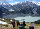
Looking across Lake Pukaki towards Aoraki Mount Cook which was obscured by cloud this morning. Image: LEARNZ.

Jana finds Shelley using an avalanche transceiver. How does a transceiver work? Image: LEARNZ.

Walt and Alvin take a look at a personal locator beacon. How do these beacons work? Image: LEARNZ.

Paul uses Agrimap to record a soil testing task to which he was assigned by the farmer. What else can Agrimap be used for? Image: LEARNZ.

Paul shows Shelley how Agrimap can be used to record any farm activities. Image: LEARNZ.