You can contact LEARNZ, part of CORE Education, at:
Postal Address:
PO Box 13 678,
Christchurch 8141,
New Zealand
Videos that are recorded and edited during the field trip will be linked here.
1. Drones and their uses mp4 file (70Mb) or watch on Vimeo.
Come down to the shores of Lake Pukaki to fly a drone and find out more about their uses.
Next step learning: Find out about some other uses of drones in New Zealand.
2. Drones monitoring wilding pines mp4 file (76Mb) or watch on Vimeo.
Drive towards Tekapo to find some wilding pines and see how drones are used to help control this invasive weed.
Next step learning: Design your own drone for a particular use in the high country.
3. What is GPS? mp4 file (64Mb) or watch on Vimeo.
Drive up to the top of Mount John to learn about GPS and how it has changed the way we locate things in New Zealand.
Next step learning: Find out the exact location of your home using GPS.
4. GPS in New Zealand mp4 file (68Mb) or watch on Vimeo.
Take shelter inside to find out more about GPS use in New Zealand and how it has changed the way we find locations.
Next step learning: Find out how GPS can be used to better prepare for natural hazards.
5. Let’s start geocaching mp4 file (86Mb) or watch on Vimeo.
Meet students from Twizel Area School to see how you can get involved in geocaching.
Next step learning: Go to the Geocaching website to find geocaches in your local area.
1. Weeds in the High Country 95Mb mp4 file or watch on Vimeo.
Meet Neil Bolton from the Department of Conservation to find out about weeds in the high country and the problems they cause.
Next step learning: Find out about weeds in your local area and what can be done to control them.
2. Pest animals in the High Country 103Mb mp4 file or watch on Vimeo.
There are many introduced predators in the high country, find out more about some of the more common predators and what is being done to manage them.
Next step learning: What do you think is the worst predator in New Zealand and why?
3. Collar that pesky pig! 70Mb mp4 file or watch on Vimeo.
Meet Billy Joe, a working dog used for pig hunting and other conservation work and find out how his collar works.
Next step learning: What are some of the other ways that tracking collars are used for conservation work?
4. Tracking Chamois and Thar 58Mb mp4 file or watch on Vimeo.
Check out the stuffed chamois and thar and find out how these introduced animals affect the high country and what’s being done to reduce their impact.
Next step learning: Find out where chamois and thar come from and why they were introduced to New Zealand.
5. Rabbit Control and GIS 127Mb mp4 file or watch on Vimeo.
Meet Sue Anderson, a Ranger for the Department of Conservation, and discover how technology is helping to control rabbit numbers in parts of the Mackenzie Basin.
Next step learning: Where else is GIS used and why is it such a useful tool?
1. Using GIS and sharing data 78Mb mp4 file or watch on Vimeo.
Meet Jana Kaeppler from the Mackenzie District Council and find out about the GIS she has created.
Next step learning: Take a look at your own local council website and see what you can find out about from the maps they have online.
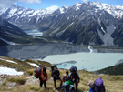
2. Location technology for recreation 85Mb mp4 file or watch on Vimeo.
Enjoy the views across Lake Pukaki near Twizel and find out about the technology that can be used for recreation in the high country.
Next step learning: How do you think technology has changed recreation in the high country?
3. What is Agrimap 59Mb mp4 file or watch on Vimeo.
Drive down to Kurow to a sheep and beef farm to find out more about how technology is being used.
Next step learning: What other forms of technology do you think would be useful to farmers? Think of some examples and how they might be created.
4. Using Agrimap 57Mb mp4 file or watch on Vimeo.
Go out and help Paul to complete a task assigned through Agrimap.
Next step learning: Find out about other technologies used by farmers in the high country.
5. Field trip summary 40Mb mp4 file or watch on Vimeo
Take some time at the end of the High Country hi-tech field trip to think about all you have learned.