Latitude and Longitude
Latitude and longitude are two of the most basics terms in all of geography. To understand them, you need to think of Earth as a globe. Then you need to think of the globe as being divided into lots of little sections. Some go east. Some go west. Some go north. Some go south.
Latitude and longitude can be shown as imaginary lines running around the earth. They are used to identify where we are.

Latitude: These are the lines that run across the globe. The latitude that runs through the middle of the Earth is given the number zero degrees (0°) and is called the equator. The latitude line at the north and south poles is given the number 90°.
Longitude: These vertical (up and down) lines around the earth meet at the poles and are widest apart at the equator. Zero degrees (0°) longitude is in Greenwich, England. The degrees continue 180° east and 180° west of the 0° line. Where they meet in the Pacific Ocean is called the International Date Line.
Every point on the Earth has its own latitude and longitude ‘coordinates’. You can use this website to find your latitude and longitude coordinates.
Making Maps
The Earth is a sphere (a ball) so making a map of part of the Earth on a flat piece of paper is rather tricky. Think of peeling an orange. The peel is like a map when flattened out.
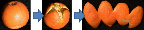
Flattening out the orange peel is like drawing the surface of the Earth on a flat surface. This process is called ‘map projection’. A map projection is used to draw all or part of the round Earth on a flat surface. All map projections distort the surface in some way. There are different types of map projections. Here are just two;
One projection called an ‘interrupted projection’ produces a map a bit like our orange peel. Note that the distances between points in high latitudes is distorted.

A common projection is called the ‘Mercator projection’. The east-west scale is the same as the north-south scale but high latitude areas such as Greenland and Antarctica have exaggerated sizes. It is not used much in New Zealand.


