You can contact LEARNZ, part of CORE Education, at:
Postal Address:
PO Box 13 678,
Christchurch 8141,
New Zealand
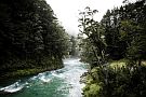
During this field trip you will explore the Waikanae River and see how it is being restored.

The Waikanae River flows from the western foothills of the Tararua Ranges about 50 kilometres north of Wellington.
The upper catchment covers 125 square kilometres of mostly regenerating native bush, mature forest and pasture.
The Waikanae River meanders through a variety of landscapes. The catchment has changed a lot over the years due to human activities and development.
Middens, observation posts, pā and burial grounds are reminders of early Māori who moved through the area.
The area is sacred to the people of Te Ati Awa ki Whakarongotai who are tangata whenua of this area.
In 1886 the Manawatu Railway opened the coast to more European settlement. Flax milling and farming settlements led to the removal of coastal forest, exposing the river’s edge to erosion.

The river has been affected by:
The Waikanae River is valued by the local community and used for a variety of purposes including:
As people live next to the Waikanae River they are at risk of being flooded, when river levels get too high. A major flood in the Waikanae River could cause millions of dollars’ worth of damage.
To mitigate the risks of flooding, Greater Wellington Regional Council has developed a Floodplain Management Plan, which outlines the different ways that flooding can be mitigated or managed. Some of the common ways outlined in the plan for managing flooding are:

The Waikanae River Catchment is being restored by local Iwi, local community groups, DOC, Kāpiti Coast District Council and Greater Wellington Regional Council.
Ready for a quiz? Try the Waikanae River interactive activity.
The Waikanae catchment is one of 14 which has also received extra government funding, recognising the high level of biodiversity, local partnerships and the potential to increase te mana o te wai – the quality and vitality of this river.
The Kāpiti Marine Reserve will also benefit from Waikanae River restoration as cleaner water enters the sea.
Iwi, local community groups, councils and DOC are working together to restore the river by: