You can contact LEARNZ, part of CORE Education, at:
Postal Address:
PO Box 13 678,
Christchurch 8141,
New Zealand
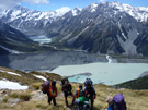
The high country covers a large area and it is important to know where you are and where places are located. Maps and technology have made it easier to find the exact locations of things in the high country.
Technology is helping people to manage the high country. Technology and maps that help locate places in the high country are helpful to;
Everybody and everything is somewhere. The ‘where’ is a location on the ground. A map shows where things on the ground are. Everyday we use and collect information about where things are; this information is called geospatial data.
We all have some understanding of where we are. When you close your eyes you can imagine where you are. For example, with your eyes closed you can point to the door you used to enter the room you are in. You might be able to point to where you live or where your school is. We all hold pictures in our heads that help us decide how to move across the school grounds, or travel home. These pictures include information that we have learnt during our lifetime.
Information about where things are located is called geospatial information or geospatial data.
Since the time of cavemen, humans have needed to know where they are and where to go to find food and shelter. People have been drawing pictures to show where things are for a very long time. Now technology is making this process easier.
How do you use technology to help you know where you are?
Māori named every feature of the land, forming an oral map, often told as a kōrero or whakapapa. In some cases posts or piles of rocks were used to mark boundaries. Māori did not draw maps.
Information for making maps was first collected by people who recorded what they saw. These people were often sailors or explorers. People who have the job of making accurate measurements of the surface of the Earth so we can make maps are called surveyors. These days aerial photos and satellites give us very accurate data about the surface of the Earth.
These imaginary lines run around the earth. They help to show where we are.

Latitude: These are the lines that run across the globe. The latitude that runs through the middle of the Earth is given the number zero degrees (0°) and is called the equator. The latitude line at the north and south poles is given the number 90°.
Longitude: These vertical (up and down) lines around the earth meet at the poles and are widest apart at the equator.
Every point on the Earth has its own latitude and longitude ‘coordinates’. You can use this website to find your latitude and longitude coordinates.
The Earth is round so making a map of part of the Earth on a flat piece of paper is a bit tricky. Think of peeling an orange. The peel is like a map when flattened out.
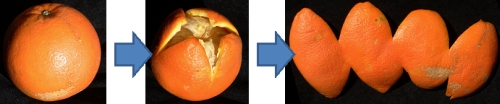
Flattening out the orange peel is like drawing the surface of the Earth on paper. This process is called ‘map projection’. A map projection is used to draw all or part of the round Earth on a flat surface. All map projections distort the surface in some way. There are different types of map projections.
Can you find out more about what type of map projections there are?

,An example of an old provincial map of Otago. Image: LINZ.

,An old map of Wellington shows property boundaries. How would maps like this be used? Image: LINZ

This map shows old place names. Which names have been changed since this map was printed? Image: LINZ.
Think about the maps you have used over the last month. How were these maps made? How much information do they include?