You can contact LEARNZ, part of CORE Education, at:
Postal Address:
PO Box 13 678,
Christchurch 8141,
New Zealand
Surveyors are experts in measurement and finding out exactly where things are located.
For thousands of years people have needed to measure the land and set out areas for buildings. The best way to show this information is on a map. The first step in making a map is to collect geospatial data. Today surveyors do most of this work.
Surveyors are experts in measurement: they collect and use spatial information. Surveyors collect and use different sorts of geospatial data:
Once accurate geospatial data has been collected and recorded by surveyors, it can be shared in different forms:
Surveyors use special tools to help them measure:
 on a tripod")
,Surveyors use special tools to help them measure. In this photo Lloyd McGarvey from LINZ uses an electronic theodolite with a laser (called a total station) on a tripod. Image: LEARNZ.

,Paula Gentle is a Geodectic Surveyor with LINZ. Paula's job is to ensure that the coordinates on survey marks throughout New Zealand are correct. Why do you think this is important? Image: LEARNZ.

,A total station in use above an opencast coal mine. Surveying on a mine site helps to pinpoint where a resource is and if land movement is occurring due to mining. Image: Solid Energy.

Image: LINZ.
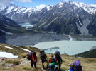
What do you think surveying is used for in the high country?