You can contact LEARNZ, part of CORE Education, at:
Postal Address:
PO Box 13 678,
Christchurch 8141,
New Zealand
Topographic maps show features that appear on the Earth’s surface.
Topographic Maps are helpful in the high country because they show land features and the shape of the land (topography).
A topographic map shows the following features;
The level of detail shown on maps depends on the scale of the map. A small scale map shows less detail than a larger scale map.
The most commonly used topographic map in New Zealand is the Topo50 map. These maps are at a scale of 1:50 000 which means one centimetre on the map equals 50 000 centimetres, or 500 metres on the ground.
Topo50 maps show geographic features in detail. They are useful for a wide range of activities, such as;
Topographic maps include a north point. This shows the direction of Grid North and Magnetic North and is used to orient the map.
The legend on a map shows the symbols used to represent features on the ground. These features include roads, tracks, rivers, lakes, vegetation, fences, buildings, power lines etc. Given the size of the map it is not possible to show all features on the ground. Symbols are grouped in themes on the legend.
Topo50 maps show 20 metre contour lines. These lines join points of equal height and show the shape or height of the land. Contour lines that are close together show steep land. Contour lines that are far apart show that the land has gentle slopes.
Map coordinates can be shown as:
To find out more about reading topographical maps go to the 36 page LINZ Topo50 Map guide (PDF 1.5Mb).
Visit the online topographic maps at http://www.topomap.co.nz/.

,This is a Topo50 map made by LINZ which shows features that appear on the Earth's surface in a certain area. Image: LEARNZ.

,All maps have a legend which shows the symbols for certain features that are shown on the map. Image: LEARNZ.

,Contour lines are shown at 20 metre intervals on Topo50 maps. Notice how the contour lines beneath the summit of Mount Rolleston are very close together indicating steep terrain. Image: LEARNZ.

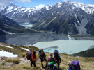
Many different people rely on topographic maps. Anyone venturing into the outdoors needs to take a topographic map with them to ensure they know where they are and where they are going. Image: LEARNZ.
Take a look at a Topo50 map of your local area and locate where you live on the map.