You can contact LEARNZ, part of CORE Education, at:
Postal Address:
PO Box 13 678,
Christchurch 8141,
New Zealand
Global Positioning Systems or GPS are used to find the exact location of things. Geographic Information Systems or GIS are used to record information on to maps. Both GPS and GIS are useful in managing land in the high country.
GPS Stands for Global Positioning Systems and they are now used throughout the world. A GPS unit is actually a receiver that collects signals from satellites.
Global Positioning System satellites transmit signals to GPS receivers on the ground. Receivers require a clear view of the sky, so they are only used outdoors and do not perform well in forests or near tall buildings.
Each GPS satellite has an atomic clock and sends a signal stating its location and the exact time. All GPS satellites transmit at the same instant. The signals move at the speed of light and arrive at a GPS receiver at slightly different times because some satellites are further away than others. The distance to the GPS satellites can be calculated by estimating the amount of time it takes for their signals to reach the receiver. When the receiver estimates the distance to at least four GPS satellites, it can calculate its position in latitude, longitude and height.
Watch this Youtube video to find out more about how GPS works.
GPS has many uses, for example;
How do you think GPS is used in the high country?
Maps have come a long way since people first began drawings to show where they were. Modern maps are created using special software that combines lots of different sorts of information. This system of modern mapping is called GIS – Geographic Information Systems. GIS is used by organisations, such as city councils, that need access to data and need to be able to combine different data sets together. GIS gives people in these organisations graphical representations of data that allows them to:
GIS requires four things:
Data contained in a GIS system is stored in sets of data called ‘data sets’ in a database. Data sets can be selected, combined and presented as layers:


,Nic Donnelly from LINZ shows the GPS equipment used for finding exact locations during surveying work. Image: LEARNZ.

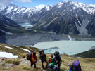
,GPS devices are useful for activities such as tramping and climbing where it is important to know where you are. Image: LINZ.

,Car navigation systems use GPS to give directions. What are the advantages and disadvantages of using a Car navigation system? Image: LINZ.

The Mackenzie District Council uses a GIS map to record different layers of information. Why might this be useful? Image: Mackenzie District Council Online Map Viewer.
If you were wanting to develop a piece of land in the high country how would you use GPS and GIS to make this easier?