You can contact LEARNZ, part of CORE Education, at:
Postal Address:
PO Box 13 678,
Christchurch 8141,
New Zealand
The Mackenzie Country is an area of high country between the Southern Alps and foothills of South Canterbury which is used for farming, tourism and to generate hydro-electric power.
The Mackenzie Country is an intermontane basin located in the Mackenzie and Waitaki Districts, near the centre of the South Island of New Zealand. It is the largest basin of its kind in New Zealand.
In the past the Mackenzie Country has mainly been used for sheep farming, but more recently it has also become a popular tourist destination. The basin extends approximately 100 kilometers north to south, and 40 kilometers east to west. The Southern Alps form the western edge of the basin.
The basin was named in the 1850s after James McKenzie, a shepherd and suspected sheep thief from Scotland. McKenzie was captured for stealing sheep from a large sheep run. He claimed innocence and escaped. He was recaptured and sentenced to five years hard labour, but escaped twice more. Later, his trial was found to be flawed, and he was pardoned. He was admired as a rebel who challenged the wealthy leaders of the time.
You could find out more about the history of the Mackenzie Country.
The MacKenzie Country has been shaped by tectonic uplift along the Alpine fault and by glaciation. Huge glaciers carved out u-shaped valleys thousands of years ago and the large glaciers and snow fields in the Southern Alps continue to feed the large braided rivers that cross the basin.
Major rivers crossing the Mackenzie Basin include the;
The Mackenzie Basin is well suited to generating hydro-electricity and the artificial hydroelectric lakes of Ruataniwha, Benmore and Aviemore have been created.
Other lakes in the Mackenzie Country include;
Around 3000 people live in this area in five settlements at;
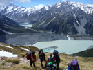
Tourism is an important part of the local economy with sightseeing and skiing attracting thousands of visitors each year. The Ohau skifield near Omarama, and Roundhill and Mount Dobson Ski Areas at Lake Tekapo, are small commercial skifields popular amongst many living in Canterbury and Otago.
Gliding is another common activity within the Mackenzie Basin. The area was host to a Gliding World Cup event in 1995.
Due to its clean, dry and dark sky, the Mackenzie Basin is an important area for New Zealand-based astronomy, and is home to the University of Canterbury's Mount John University Observatory which is also visited by many tourists.
What other tourist attractions are there in the Mackenzie Country?
The Mackenzie Country is also a popular location for filming television commercials, documentaries, and motion pictures, including much of Peter Jackson's epic 'The Lord of the Rings' film trilogy and 'The Hobbit' film trilogy.
Māori and European settlement in the Mackenzie Country has transformed the once forested land into tussock grasslands. More recently new farming operations have changed the region with the introduction of irrigation and more intensive dairy farms. Water and waste management is now an issue for the area.
The extensive network of canals for hydroelectric schemes posed a threat to the Black Stilt (or kaki), an endangered river wading bird. A captive breeding programme was set up and it is run by the Department of Conservation.
The MacKenzie Basin is one of the areas where wilding pines have spread. These weed trees cover large areas and if left can exclude native vegetation and reduce the amount of available pasture. Some areas have control measures in place to prevent the trees from spreading.
Rabbits are also a problem in the area affecting farms and native plant species. The Department of Conservation is using 1080 to control rabbits.

,The Mackenzie Country is an area of high country near the centre of the South Island. How would you get from Dunedin to the Mackenzie Country; which roads would you travel on? Image: Ingolfson.

,Aoraki Mount Cook, the highest peak in New Zealand, can be seen across Lake Pūkakī in the Mackenzie Country. How high is Aoraki Mount Cook? Image: Shaun Muckle.

,There are large lakes in the Mackenzie Country. The Ben Ohau Range can be seen across this lake. What lake do you think this is? Image: Shaun Muckle.

A series of canals have been built to link the dams and hydro schemes in the area. How many dams are there in the Mackenzie Country. Image: Avenue.
Imagine you live in the Mackenzie Country; what do you think it would be like? Discuss the advantages and disadvantages of living in this area.