fbpx Adding More Information to Maps with GIS | LEARNZ

Adding More Information to Maps with GIS

«Previous
GPS Global Positioning Systems
Next»
Tools for Mapping
Listen: 

GIS stands for Geographic Information System. GIS uses software to put different layers of information on a map.

Layer upon layer

Maps have come a long way over time. Modern maps are made using special software that uses lots of different information. This system of mapping is called GIS – Geographic Information Systems.

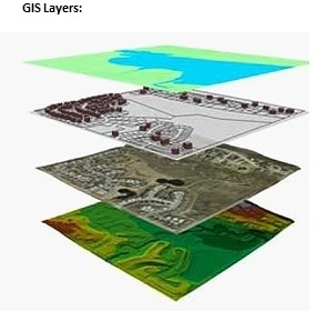
GIS gives access to data and can show different sets of data together or separately as layers on a map:


GIS gives people a picture of data that allows them to:

  • problem solve
  • write reports
  • track changes
  • make decisions
  • plan for the future e.g. which areas could be used to build houses.

Learning with GIS

GIS gives new ways of thinking about and seeing the world around you. Using GIS in projects helps to develop research and presentation skills.

GIS helps thinking and problem solving skills. It is also being used in a number of jobs today, so learning to use GIS helps with future careers. You may even be part of a community project that benefits from using GIS.


Audio Māori keywords: 


What info? If you were planning a school camp, what information would you want to see on a GIS map of possible camping locations?

Within two hours of the February 22 2011 earthquake in Christchurch, Eagle Technology Ltd had a Christchurch Earthquake Incident Viewer up and running on the internet. This showed the public important information overlaid on to a map. Image: Eagle Technology Ltd.

This map is one of many created as part of the Ngāi Tahu Cultural Mapping Project. This one shows places where Mahinga kai/traditional food and other natural resources were gathered by their tīpuna. Image: Te Rūnanga o Ngāi Tahu.

«Previous
GPS Global Positioning Systems
Next»
Tools for Mapping