Tāhuhu Kōrero - Background History
The tribes of Taranaki are descended from three main ancestral canoes: Tokomaru, Kurahaupō and Aotea. These three waka were part of a major fleet of seven canoes that arrived to Aotearoa over 1000 years ago. Other waka are also known to have landed periodically on the Taranaki bight before and after the arrival of these more well known canoes.
Prior to the arrival of these great waka, Taranaki was occupied by a group collectively referred to as Te Kāhui Maunga. The new immigrants intermarried with these first inhabitants and their offspring continue to live in the region within the traditional boundaries known as Parininihi in the north to Taipake in the south.
A prominent landmark that dominates the peninsula is the majestic Taranaki maunga. Taranaki’s fertile slopes were once clothed with beautiful native flora and home to numerous native and endemic birds and insects. These mountains were once occupied by the original Te Kāhui Maunga residents, where they built villages, pā, and where they cultivated and harvested various food sources such as kumara and mamaku (black tree fern).
The journey of Taranaki and the guide stone Te Toka a Rauhoto
Taranaki maunga once lived with the mountains Tongariro, Ruapehu, Ngauruhoe, Tauhara, Putauaki, and Pihanga in the middle of Te Ika a Māui. Taranaki fell in love with the beautiful Pihanga but she was desired by other maunga. Conflict over Pihanga tore apart the community. Tongariro was the eventual victor and Taranaki was forced to leave his home.
With great sadness Taranaki travelled west and during the journey he was led by the stone Te Toka a Rauhoto. Rauhoto and Taranaki followed the Manganuiteao awa to the Whanganui awa. They then headed to the west coast and rested at Ngaere swamp. Their migration ended when Taranaki settled next to the two maunga named Pouakai and Patuha. These maunga welcomed Taranaki and he has stood there ever since.
Pukeonaki and Pukehaupapa are earlier names for Taranaki. The whakataukī ‘Te Ahi a Tahurangi’ - 'The fire of Tahurangi’ commemorates the tupuna Tahurangi claiming the mountain for Taranaki iwi by lighting a ceremonial fire on the summit.
Te Toka a Rauhoto sat between the Hangataahua awa and Werikino awa and for many generations was revered as the guidestone of Taranaki maunga. A well known kaitiaki of the stone from Ngā Mahanga was Minarapa Kahukura Makuru.
In 1948 the people of Ngā Mahanga decided that Te Toka a Rauhoto should be moved from where it rested next to Otaunui (on Komene Road) to Puniho Pā. The tohunga Te Ao Mārama was tasked to lift the tapu so that it could be relocated safely. Te Toka a Rauhoto was shifted to its present location on Wednesday 22 December 1948.
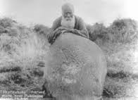
Minarapa Kahukura Makuru. Image: Scanlan 1961:64.

About the field trip
This field trip provides students an opportunity to learn about the stories related to the maunga from a Taranaki indigenous perspective. It is an opportunity to share information to help people become better informed about appropriate cultural practices on the maunga.
The field trip experience is an opportunity to empower tamariki and whānau to be proactive in environmental initiatives. Involvement in this field trip will have positive outcomes on the cultural health and well-being of those involved. It is an effort to connect tamariki to the maunga with the aim of inspiring individuals to engage with like-minded environmental caretakers.