Landslides in Aotearoa
Landslides are a natural process that remove material from hills, mountains and coastlines. Landslides are common in Aotearoa New Zealand because we live on the boundary between two major tectonic plates, which leads to frequent earthquakes and volcanic activity.
Landslides in New Zealand can range from small- to large-scale events, causing damage.
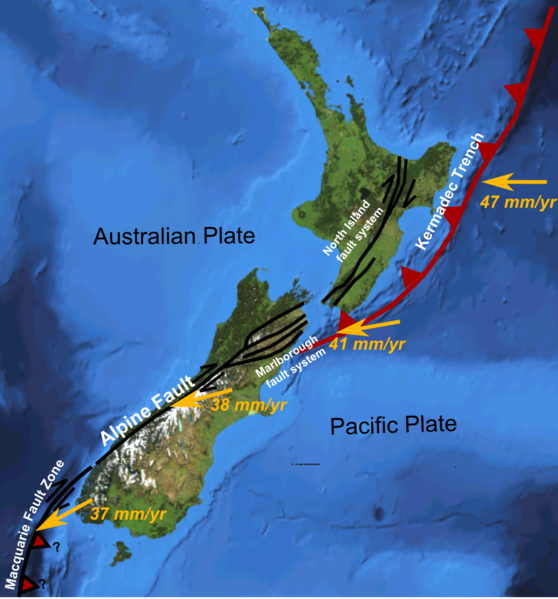
Tectonic movement makes landslides common in Aotearoa. Image: Wikimedia.
Unstable land
Compared to many other countries, Aotearoa has a high number of landslides because:
land is tectonically active
weak layers of rock are common
earthquakes are frequent
there is a lot of hill country, often without bush
rainfall is high.
Landslides are New Zealand's deadliest natural geological hazard, causing more loss of life than earthquakes, volcanic eruptions and tsunami combined. Landslides in New Zealand are most commonly triggered by heavy rainfall and earthquakes.
Rūaumoko
In te ao Māori (the Māori world), Rūaumoko is the youngest child of the atua Ranginui and Papatūānuku. Deep underground, he’s the playful little brother making the whenua move.
Rūaumoko shows us that the land is alive and moving, whether through earthquakes, volcanic eruptions, or landslides. While some of these changes happen so slowly that people barely notice, others happen suddenly, completely changing the shape of Aotearoa New Zealand’s mountains, valleys, and coastlines. This restless energy under our feet has been shaping Aotearoa for millions of years.
Matauranga Māori
Because Māori have lived closely with the land for a very long time, they have learned a great deal about local natural hazards such as earthquakes, volcanoes, floods, and landslides. This important knowledge has been passed down through:
Pūrākau - sharing stories about historic natural hazard events so people would remember and learn from them.
Tapa whenua - assigning place names to certain areas to warn people that a place might be dangerous.
Tohu | environmental indicators - learning to read the environment—like watching how the land, plants, animals, or weather changed—to know when it was safe to do things.
This traditional knowledge, known as Mātauranga Māori, can help groups and councils plan and keep people safe from future natural disasters.
Major landslides in Aotearoa New Zealand
Green Lake, Fiordland (13,000 Years Ago)
This is New Zealand’s largest documented landslide. An entire chunk of a mountain range collapsed in a massive rock landslide. The falling debris covered a huge area of over 45 square kilometres. Instead of forming small ponds like typical landslides, the massive depressions left behind in the uneven terrain filled with water, creating sizable lakes such as Green Lake, which we see today.
Waihī, Lake Taupō (1846)
This remains the deadliest landslide in New Zealand's recorded history. Days of heavy rain blocked a stream and built up a makeshift dam at Kākaramea. When that dam suddenly collapsed three days later, it sent a massive, fast-moving mudflow down the valley that overwhelmed Te Rapa, a small village, killing 60 people including chief Mananui Te Heuheu.
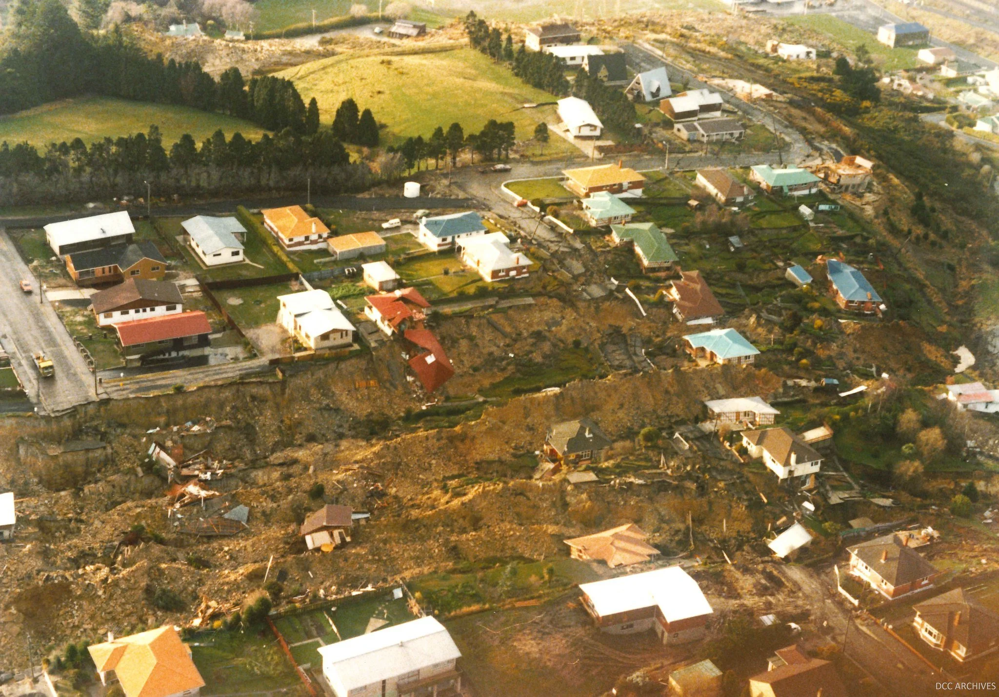
Abbotsford landslide in Dunedin left 69 homes uninhabitable—image: DCC archives, Civil Defence.
Abbotsford, Dunedin (August 1979)
This was New Zealand's largest historical landslide in a built-up area. After years of subtle underground movement, a massive wedge of land in the Dunedin suburb of Abbotsford suddenly slid downhill at a speed of about 3 meters per minute. The culprit was a layer of clay beneath the surface that became lubricated by water, causing the rock above it to slide off.
The slide dragged 17 people and many houses along, leaving 69 homes entirely uninhabitable. Miraculously, because the land moved slowly enough for residents to escape, no one was killed.
Cyclone Gabrielle (February 2023)
One of the most extreme landslide-triggering events ever recorded anywhere in the world. A tropical cyclone dumped huge amounts of rainfall across the upper and eastern parts of the North Island, triggering more than 800,000 landslides. This massive, widespread movement wrecked roads, tore down forests, isolated communities, and destroyed homes.
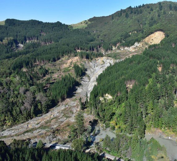
Cyclone Gabrielle triggered thousands of landslides across the North Island—image: Earth Sciences NZ.
Mauao ❘ Mount Maunganui (January 2026)
A devastating, localised disaster driven by intense weather. Record-breaking summer rainfall oversaturated the slopes of Mauao ❘ Mount Maunganui, triggering a sudden landslide. The torrent of mud and debris buried the Mount Maunganui Beachside Holiday Park located at the base of the mountain. The event resulted in six tragic fatalities and forced the immediate evacuation of the surrounding area.
Stay Informed
Landslides can happen quickly during severe weather events. For the most up-to-date regional landslide warnings and active event reports across New Zealand, always check the GeoNet Landslide Reports.