Land, Sky and Space: accurate satellite positioning takes off!
Fly in the cockpit of a regional aircraft, travel in self-driving vehicles, see how rockets get into space and how we make rural land more productive.
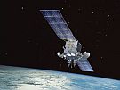
IntroductionWe all rely on knowing where we are and the location of things. Location-based technology is improving all the time, it allows us to navigate safely, travel the world and manage the environment around us. On this field trip you will jump aboard a self-driving vehicle at Christchurch Airport to discover how these vehicles know where to go and how to keep passengers safe. Following this test-ride you will board a domestic Air New Zealand flight destined for Invercargill. During this flight you will see how pilots use the latest technology to safely navigate. While in Invercargill you will investigate the latest satellite based navigation system, visit a ground station and look at how location-based technology is helping local council experts to better manage parts of the Southland environment. Using Google Maps you will navigate your way north to the City of Dunedin where you will meet University of Otago surveying students and experts who are helping to create more accurate property boundary maps of rural areas. Find out more about the growing number of jobs available in the geospatial industry and how you can utilise location-based technology in your day to day life. Meet Shelley the LEARNZ field trip teacher Watch the introductory video on Vimeo. LocationYou will begin your field trip in the Garden City of Christchurch, the largest city in the South Island. You will then take a 90 minute flight on a turbo-prop plane to Invercargill, our most southern city and home to around 55,000 people. You will drive two and a half hours north to end your field trip in the University town of Dunedin, the second largest city in the South Island.
|


Field Trip Plan - May 2018
Monday 21 May |
Travel Day
|
|
Tuesday 22 May |
Self-driving vehicles and flight navigation
|
|
Wednesday 23 May |
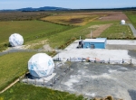
Satellite navigation and aerial imagery
|
|
Thursday 24 May |
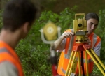
Rural surveying and mapping
|

![]()