Imaginary lines
Latitude and longitude are two of the most basics terms in all of geography. To understand them, you need to think of Earth as a globe. Then you need to think of the globe as being divided into lots of little sections. Some go east. Some go west. Some go north. Some go south.
Latitude and longitude can be shown as imaginary lines running around the earth. They are used to identify where we are.
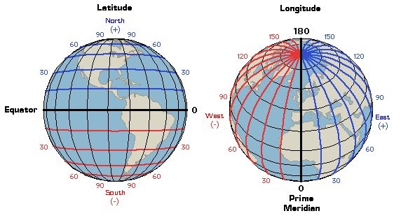
Latitude: These are the lines that run across the globe. The latitude that runs through the middle of the Earth is given the number zero degrees (0°) and is called the equator. The latitude line at the north and south poles is given the number 90°.
Longitude: These vertical (up and down) lines around the earth meet at the poles and are widest apart at the equator. Zero degrees (0°) longitude is in Greenwich, England. The degrees continue 180° east and 180° west of the 0° line. Where they meet in the Pacific Ocean is called the International Date Line.
Every point on the Earth has its own latitude and longitude ‘coordinates’.
What is geospatial data?
Everybody and everything is somewhere. The ‘where’ is a location on the ground. A map shows where things on the ground are. Every day we use and collect information about where things are; this is called location-based information or geospatial data.
- geo – meaning the earth
- spatial – meaning space (the space around us)
- data – means a group of facts for example numbers, words, measurements, or records of what we see.