Snowline Secrets
What glaciers tell us about our changing climate
About this field trip
Glaciers are a taonga and vital to both the health of people and te taiao, the natural environment. Our spectacular glaciers attract tourists, feed major hydroelectric power schemes, nourish delicate ecosystems, and act as highly sensitive indicators of climate change.
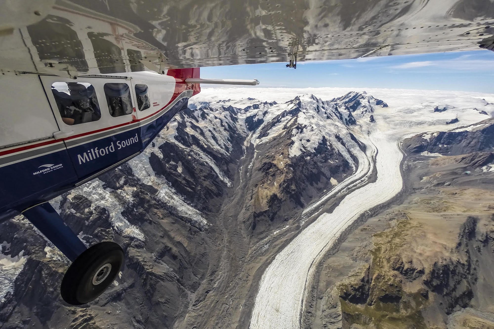
During this field trip, you will join scientists on a flight along the length of Kā Tiritiri o te Moana | Southern Alps to complete the end of summer snowline survey. This aerial survey is run by Earth Sciences New Zealand and has been carried out every year for nearly 50 years. You will explore the importance of glaciers, discover how they shape our landscape and how they are responding to our changing climate.
Objectives
The objectives of this virtual field trip are to:
increase awareness and understanding of glaciers, their formation and how they respond to changes in climate
highlight the global importance of glaciers to people and the environment
identify glacial landforms and describe how they are formed.
Key learning
Through this field trip, participants will:
explore glaciers of Te Waipounamu and the landscape they have helped shape
understand how glaciers form and how they respond to changes in average temperature and precipitation
learn how glaciologists measure glaciers and monitor changes in glaciers over time
discover the importance of glaciers to our natural ecosystems and the New Zealand economy.
Curriculum alignment
This virtual field trip aligns with The New Zealand Curriculum refresh. It covers a range of learning areas, predominantly science and social sciences. Access guidance that supports teaching and learning to align with curriculum goals.
Sustainable development goals
This trip reflects the United Nations Sustainable Development Goals (SDGs), especially Goal 13: Climate Action: Take urgent action to combat climate change and its impacts.
Educator guide
This guide is designed to support teachers in aligning the LEARNZ Snowline Secrets virtual field trip with the goals, structure, and learning outcomes of The New Zealand Curriculum refresh. It outlines the key learning intentions, suggests cross-curricular links, and provides examples of teaching and learning opportunities that are meaningful, place-based, and action-oriented.
Learning objectives
The virtual field trip is designed to:
increase awareness and understanding of glaciers, their formation and how they respond to changes in climate
highlight the global and national importance of glaciers to people and the environment
identify glacial landforms and describe how they were formed.
Curriculum vision and values
This field trip supports the vision of The New Zealand Curriculum refresh by helping ākonga to:
value the whenua, understanding how people’s actions can impact the environment
respect multiple knowledge systems, including mātauranga Māori and science.
-
Physical Science
Materials
Year 4Matter can change state if heated or cooled (e.g. melting, freezing, condensation).
Investigate by; Testing simple predictions about changes of state by heating and cooling matter.
Matter Interactions and Energy
Year 4
Temperature is a measure of how hot a substance is. It can be measured using thermometers, usually in degrees Celsius (°C)
Investigate by: Measuring temperature accurately using a thermometer. Predicting and then measuring the temperature of substances.
Year 5
Thermal energy comes from many sources e.g. the Sun.
Investigate by: Asking testable questions about thermal energy transfer.Year 6
Earth and Space
The hydrosphere is all the water on the surface of Earth.
Water regularly moves from one store to another (e.g. changing location or state).
Only a small proportion of Earth’s water is fresh water that humans and other organisms can consume.
Fresh water is also stored on Earth’s surface, including glaciers and ice caps, rivers and lakes.
Investigate by: Using data (e.g. from a weather service) to analyse changes in surface and groundwater levels (e.g. snowmelt or seasonal rainfall differences).
Communicate by: Representing (e.g. maps, scaled diagrams, pictograms, simple graphs) quantities and the distribution of water on Earth.
Physical Science
Year 7
Materials
Most matter exists as solids, liquids, and gases.
Changes of state occur when thermal energy is added to or removed from a substance.
Changes of state include melting, freezing, evaporation, condensation, sublimation, and deposition.
Water expands when it freezes because its particles form a fixed arrangement with gaps that keep them farther apart than in liquid water, so solid water is less dense than liquid water.
Investigate by: Planning and conducting an experiment to test how thermal energy impacts on changes of state.
Communicate by: Using models and representations of particles to explain the changes of state observed in the investigation.
Apply by: Identifying everyday situations where changes of state can lead to problems (e.g. water bottle in the freezer, icy roads, glacial floods).
Earth Systems
Year 9
The water cycle
Water cycles through the Earth system via evaporation, condensation, precipitation, freezing, and melting.
Changes of state influence weather patterns, including cloud formation, humidity, temperature, and precipitation.
The Sun transfers thermal energy to Earth’s surface, warming air, land, and water, with this effect decreasing as latitude increases (e.g. highest at the equator, 0°).
The amount of water on the Earth is finite, cycling through short (e.g. transpiration) and long-term (e.g. glaciers) loops.
Practices
Select data from secondary sources to examine how water storage (e.g. in glaciers, groundwater, and the atmosphere) disrupt the movement of water through the water cycle.
Model processes of the dynamic nature of the water cycle.
-
Geography
Year 5
Processes responsible for New Zealand’s diverse landscapes:
Landscapes are also shaped by the processes of erosion and deposition, fluvial (river) processes, glacial (ice) processes, and mass movement (landslips).
Frame questions:
Ask interpretive questions, for example: Why does this landscape look like that?
Process information by:
Using relief maps, aerial photographs, and cross–sections to identify landscape features.
Using diagrams to show how different erosion and deposition processes work.
Interactions between landscapes and people
In te ao Māori mountains and rivers are often considered and recognised as tipuna (ancestor), which are personified, living entities (e.g. Aoraki, Te Urewera, Taranaki maunga, Whakaari White Island).
Communicate findings and conceptual knowledge by:
Consider actions that you can take to preserve and enhance valued natural features.
Case study: Local landform landscape
The landforms of the local area have a distinctive physical appearance resulting from natural processes that have formed and modified them.
Communicate findings and conceptual knowledge by:
Describing landform differences from place to place, and the reasons for those differences (landscape formation).
Learning activities:
Create a Google Earth for web tour to locate and describe at least 5 glaciers in Aotearoa.
Complete diagrams to identify and describe different glacial landforms
Design and complete a poster or infographic to describe how glaciers benefit people
Complete a case study of a major glacier in Aotearoa showing its location, the landforms it has created, how it impacts people and how people have impacted it.
-
Oral Language
Communicating and Presenting
Verbal reasoningKnowledge:
Precise and purposeful language is needed to analyse ideas, critique perspectives, interpret meaning, and structure arguments clearly for listeners.
Creating and answering questions supports deep thinking by exploring different perspectives, testing assumptions, and considering possible consequences.
Practices:
Asking and answering open-ended questions that test assumptions and consider possible consequences.
Using spoken language to make inferences and draw conclusions by interpreting ideas, justifying thinking, and using evidence from discussion or experience.
Reading
Comprehension
VocabularyKnowledge:
Expanding vocabulary, especially academic and content-specific terms, is essential for interpreting and engaging with increasingly complex texts.
Practices:
Using a range of strategies to ascertain the meaning of academic and content-specific words and phrases in year-level texts.
Using year-appropriate academic and content-specific words and phrases with accuracy.
Comprehension strategies
Knowledge:
Readers monitor and actively manage their understanding while reading a variety of texts and sources, by applying a range of strategies — such as annotating, rereading, reading ahead, asking questions, visualising, and consulting references — to support continued meaning making.
Practices
Identifying and summarising key ideas and themes in texts, explaining how supporting details develop and connect these ideas.
Writing
Composition
Writing to informKnowledge:
Informative texts are written to communicate information, explain ideas, or present arguments clearly and logically.
Practices:
Writing texts to inform that:
clearly introduce the topic and organise ideas and information logically into paragraphs
include headings and visual features such as illustrations, charts, tables, and multimedia (when useful for aiding comprehension)
include words and phrases to clarify, illustrate, or compare ideas.
Learning activities:
Write a news article or report on how a glacier in Aotearoa New Zealand has changed over the last 25 years
Present a video journal from the perspective of glacier guide who has worked on Kā Roimata o Hine Hukatere Franz Josef Glacier for the last 15 years
Design infographics showing how glaciers shape the land
Create a poster to showcase the different values of glaciers
-
Focus concepts: Whakapapa o te whenua, kaitiakitanga, mātauranga ā-iwi
Learning outcomes:
Understand Māori perspectives on the land, signs of natural change, and ancestral stories.
Learning activities:
Explore local pūrākau about glaciers and glacial landmarks.
Compare local iwi knowledge with scientific predictions.
Learning areas and achievement objectives
Discover more
Select a topic or image link for background information, images, narrations, and kupu Māori | key words for each topic.
Ice on the move
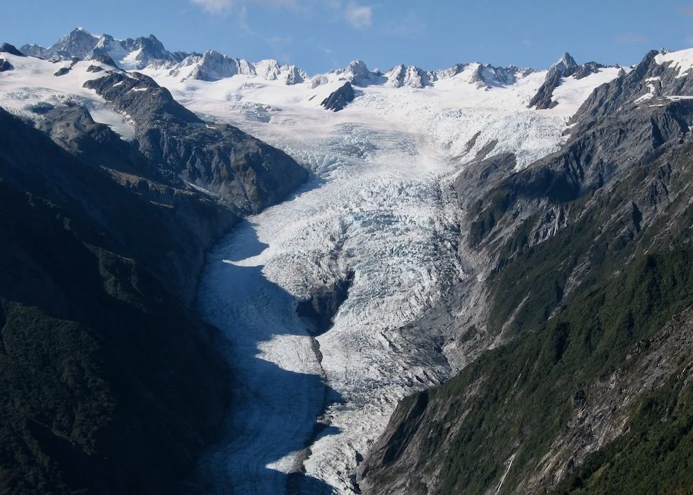
Glaciers are often called “rivers of ice.” Glaciers are giant, heavy masses of ice that move very slowly downhill.
Glaciers in Aotearoa
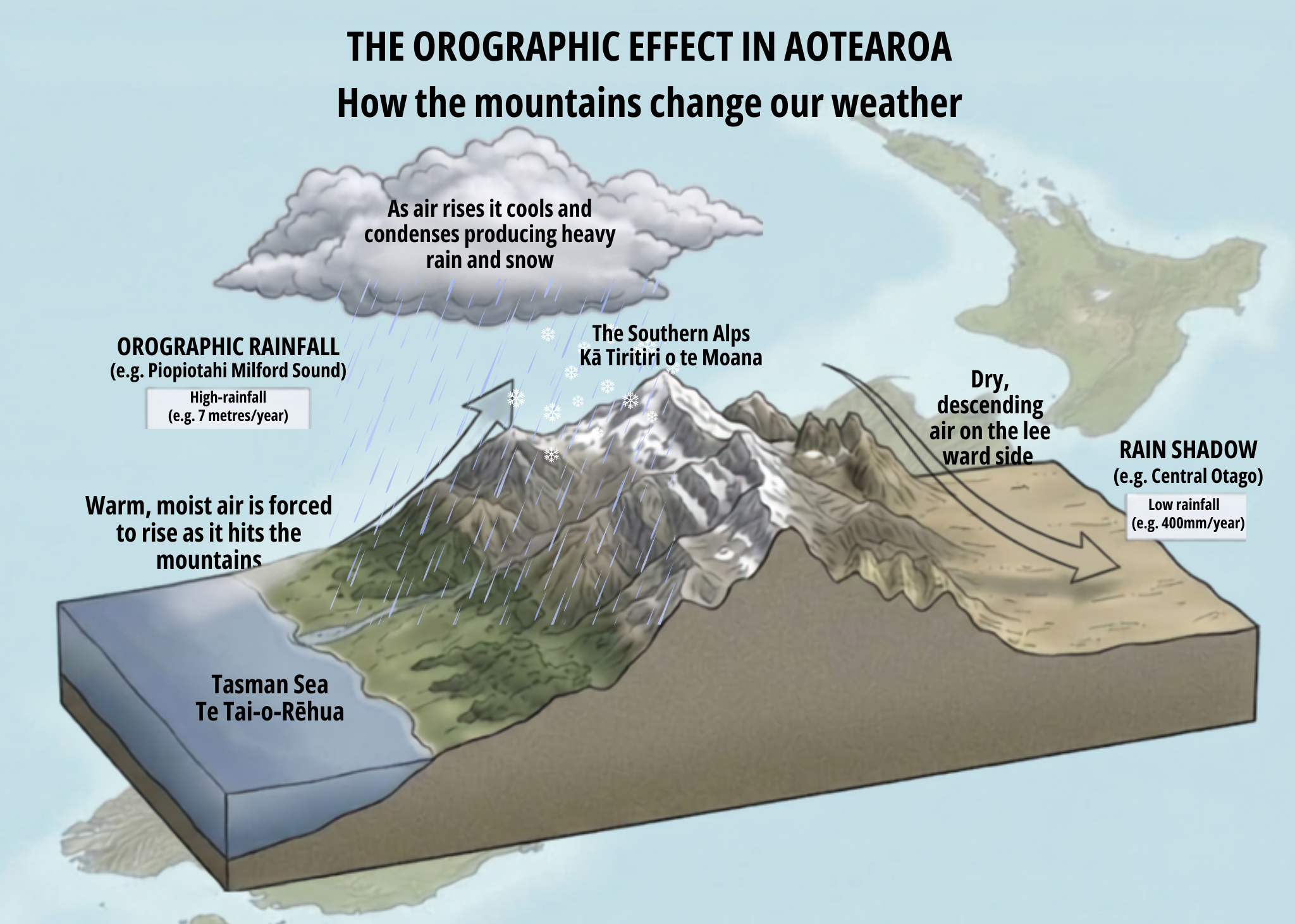
Why does Aotearoa have so many glaciers? It all comes down to our climate and plate tectonics uplifting our mountains.
Taonga glaciers
In Aotearoa, glaciers aren't just giant blocks of ice—they are taonga (treasures).
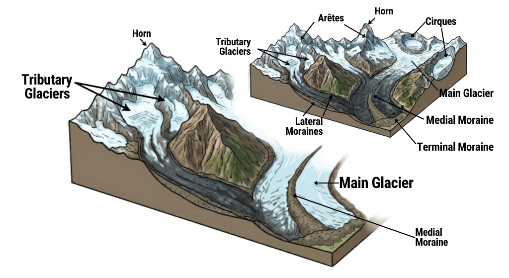
A land shaped by glaciers
Imagine a river made of solid ice, so huge and heavy that it slowly slides down a mountain. That’s a glacier.
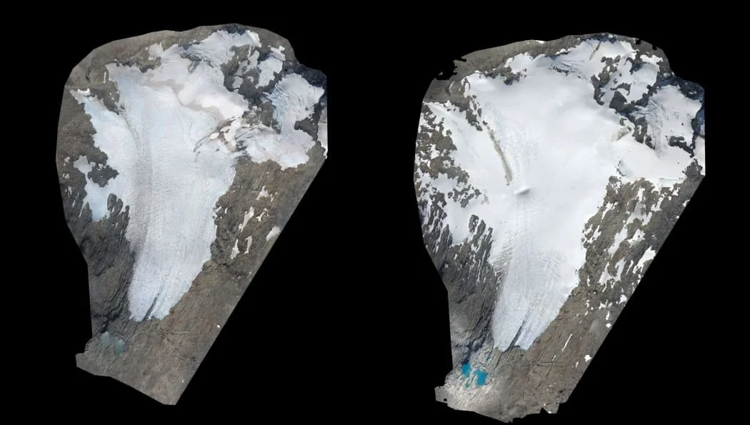
Glacier detectives
Scientists who study glaciers are called glaciologists. Climate scientists also study them to assess how temperature changes affect the environment.
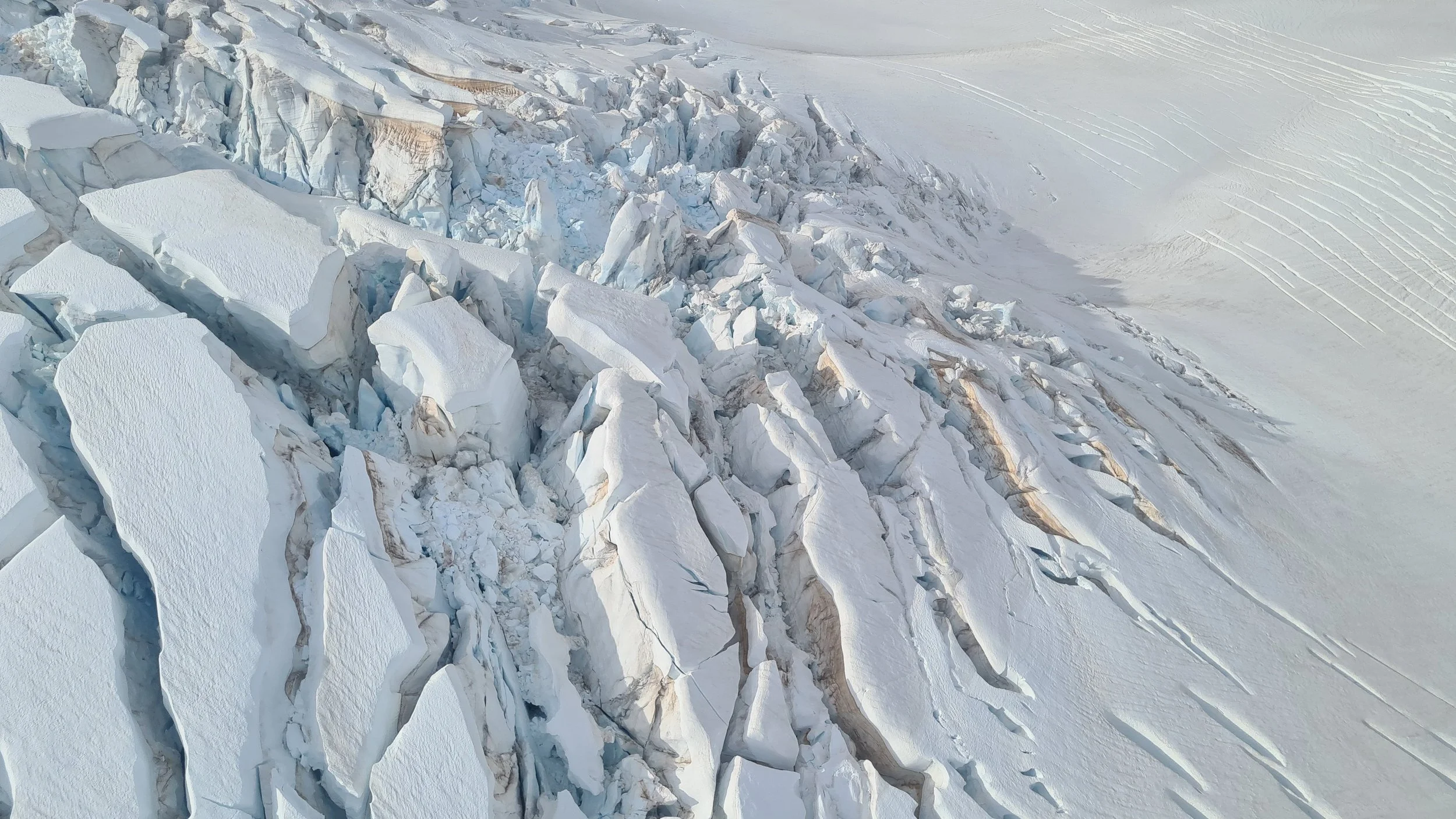
Climate change and glaciers
In Aotearoa, glaciers are incredibly special. These icy giants are an important link in our environment ki uta ki tai, from mountains to sea.
Connect with field trip experts
Insights into people and their careers.
Meet Andrew (Drew)
Andrew (Drew) is a Principal Scientist at Earth Sciences New Zealand.
Meet Lauren
Lauren is a Senior Research Fellow at Victoria University of Wellington.
Meet Brian
Brian is an Associate Professor in the Antarctic Research Centre at Victoria University of Wellington.
Explore the field trip videos
Join our field trip experts as we visit new places and learn new things.
The annual snowline and glacier survey
Join Drew, a scientist from Earth Sciences New Zealand, in Tāhuna Queenstown to discover how the snowline and glacier survey is completed and what it can tell us about our glaciers.
Check your understanding
What happens during the annual snowline and glacier survey?
How many glaciers are surveyed?
What are some of the challenges involved in completing this survey?
Our changing glaciers
Head up the Remarkables ski field road to see one of the glaciers that will be photographed during the snowline and glacier survey and discover how our glaciers are changing.
Check your understanding
What conditions are needed for glaciers to form?
How do glaciers move?
How long has the annual End of Summer Snowline and Glacier Survey been running?
Identifying glacial landforms
Look out over the Wakatipu Basin to see how glaciers have shaped this landscape. Identify different glacial landforms and how they formed.
Check your understanding
How did Lake Wakatipu form?
What is a roche moutonnée and what can it tell us about the glacier that shaped it?
How are fiords created and why does Fiordland have so many fiords?
Monitoring glaciers
Catch up with Lauren, a glaciologist from Victoria University, during the flight over Kā Tiritiri o te Moana. See how the End of Summer Snowline and Glacier Survey is completed and find out how scientists monitor and measure glaciers in Aotearoa.
Check your understanding
What equipment is used to record the glaciers during the survey?
What happens to the information recorded during the survey?
Which glacier will Lauren be completing field work on after the flight?
The importance of glaciers
Take a break from the snowline and glacier survey flight to refuel in Takapō and meet Lauren, a scientist from Victoria University. Discover why our glaciers are important in Aotearoa and globally.
Check your understanding
Why are glaciers important to people globally?
How could glacial recession affect agriculture in Aotearoa New Zealand?
How do you think glacial recession impacts alpine plants and animals?
The future of glaciers
Kōrero with Brian, a glaciologist, about his research and what the future looks like for glaciers worldwide.
Check your understanding
Why is it hard to monitor glaciers?
How has Kā Roimata-o-Hine Hukatere Franz Josef Glacier changed in the last 50 years?
Why are New Zealand glaciers melting faster than in other parts of the world?
360 degrees video of the Snowline Survey flight
Join us on the plane as the scientists undertake the snowline survey. Drag the video to take a 360 degree view.
Take the Google Earth tour
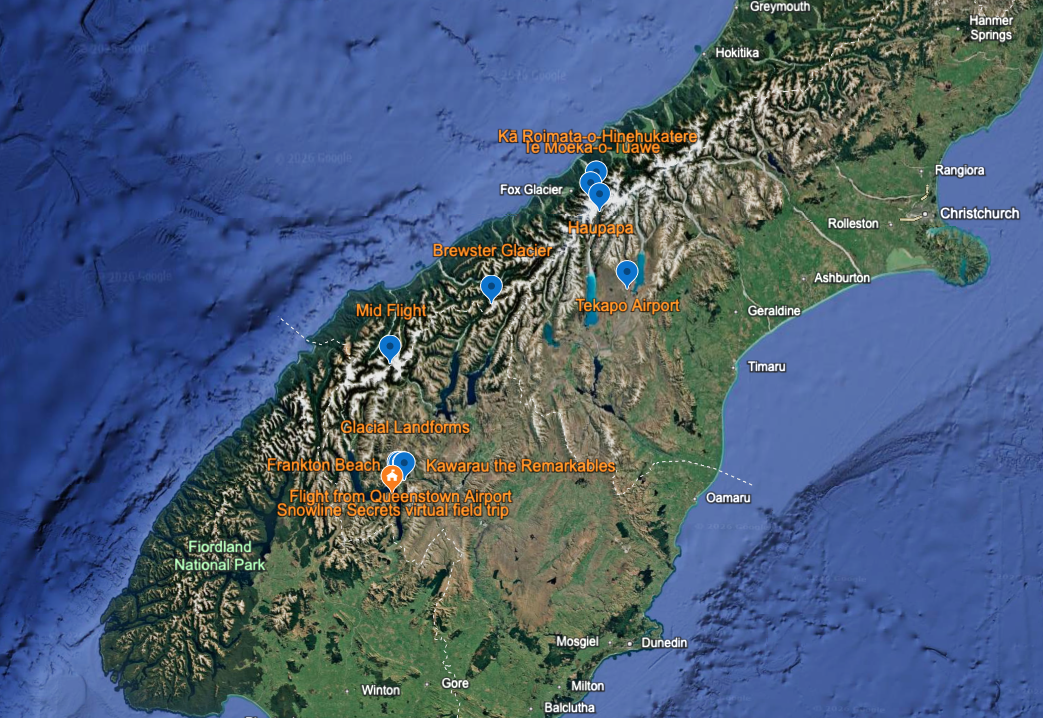
Take the Google Earth for Web Tour
A virtual tour of the field trip with GIS mapping, 3D locations, 360° panoramic images, videos, and further information.
Web conference
Replay the field trip web conference
Resources
Useful links
Earth Sciences New Zealand has a national leadership role in monitoring and researching climate and weather in Aotearoa. Check out their weather and climate teaching resources, including lessons on glaciers.
Glacier Monitoring at Victoria University of Wellington Te Herenga Waka
Te Puna Pātiotio - Antarctic Research Centre at Victoria University is involved in glacial research. Discover how they closely monitor Haupapa Tasman Glacier and Kā Roimata o Hine Hukatere Franz Josef Glacier. See timelapse video and imagery of these glaciers.
Te Ara the Encyclopedia of New Zealand - Read the story on Glaciers and Glaciation to find out more about ice ages, glaciers, glacial recession in Aotearoa New Zealand.
Science Learning Hub Pokapū Akoranga Pūtaiao - explore New Zealand science education resources on glaciers.
Climate Change and Nature - a portal for people to find information on climate change including a story on Our Vanishing Glaciers.
NIWA videos - NIWA, now part of Earth Sciences New Zealand has an awesome Youtube channel including videos on glaciers.
Manatū Mō Te Taiao Ministry for the Environment - Read this ArcGIS story map on Glaciers, Snowlines and Biodiversity.
Glossary
Ablation: How glaciers and ice shelves lose mass. This can be through surface melting and runoff, calving icebergs, or melting at the base.
Accumulation: How glaciers gain mass, chiefly through precipitation.
Advance: When a glacier grows longer because it is getting more snow at the top than it is melting at the bottom.
Arête: A narrow ridge of rock that separates two valleys. It is usually formed when two glaciers erode parallel U-shaped valleys.
Carbon dioxide: When a carbon atom joins with two oxygen atoms, a lot of carbon dioxide comes from burning things containing carbon
Cirque: A giant, bowl-shaped scoop carved out of the side of a mountain by a glacier.
Climate: The long-term pattern of weather in a particular area, typically averaged over a period of 30 years or more.
Climate Change: The rapid change in climate due to human activity (mainly burning fossil fuels) increasing heat-trapping greenhouse gases in the atmosphere.
Crevasse: A deep, dangerous crack in the glacier ice. They form because the ice stretches and breaks as the glacier moves over bumpy rocks.
Ecosystem: This is all the living (e.g. animals, plants) and non-living (e.g. light, water) things within a particular area
Erratic: Glacially-transported boulder that does not match the bedrock on which it sits (it is of a different origin).
Fiord: Formed when a glacier carves out a valley from the mountains to the sea. When the glacier melts, seawater fills the valley, creating a narrow inlet. Milford Sound is an example of a fiord.
Firn: Snow falls onto glacier surfaces, where the crystals change under the weight of snow above, turning into ice. The intermediate stage of multi-year hard snow is known as firn.
Glacials: Colder periods where ice sheets advance, global temperatures drop by roughly 5°C to 6°C, and vast amounts of water become locked up in ice, drastically lowering sea levels.
Glacier (Awa Kōpa): A huge river of ice that moves very slowly down a valley. They form when lots of snow falls in the mountains and packs down into ice over many years.
Glacier Milk: A milky, light-blue or grey river that flows out from the bottom of a glacier. It gets its colour from "rock flour," rock ground into a fine powder by the heavy, moving ice.
Global warming: When the average temperature on Earth rises.
Greenhouse effect: The natural way the Earth is warmed by gases in the atmosphere, known as greenhouse gases, which trap heat. If extra greenhouse gases are added to the atmosphere, such as from human activities, they absorb more heat, causing global warming.
Holocene: The last period of Earth’s history after global deglaciation. The last 10,000 years.
Horn: A sharply pointed, pyramid-shaped mountain summit, also known as a pyramidal peak. It forms when three or more glaciers erode the sides of a mountain. Each glacier carves out a deep, bowl-shaped hollow known as a cirque. As these ice scoops get deeper and deeper, the rock walls between them get steeper and skinnier, creating a horn.
Ice Age: A long period of Earth's history where global temperatures drop, causing the expansion of polar ice sheets and alpine glaciers. Surprisingly, our planet is technically still in an ice age that began about 2.6 million years ago.
Icefall: A section of the glacier that looks like a frozen waterfall. It happens where the mountain gets very steep, causing the ice to shatter into giant chunks.
Ice Shelf: Thick, permanent, floating sheet of ice that is derived from terrestrial tributary glaciers. Back pressure from an ice shelf stabilises its tributary glaciers, which may accelerate, recede, and retreat if the ice shelf melts away.
Ice Stream: Large outlet glacier moving at an order of magnitude faster than the surrounding ice. May be topographically confined. Ice streams transport 90% of the ice and sediment out of Antarctica. Their behaviour and stability are essential to the ice sheet's health.
Interglacial: Warmer interludes - like the current period we have been in for the last 11,000 years - when glaciers retreat, and the climate becomes much more temperate.
Last Glacial Maximum (LGM): The last time when the ice sheet reached its maximum extent, to the shelf break. In the Antarctic Peninsula, this occurred over 18,000 years ago.
Marine ice sheet: An ice sheet, such as the West Antarctic Ice Sheet, where the bed is below sea level. The bed gets deeper inland for the West Antarctic Ice Sheet, which may make it unstable.
Mass balance: Glaciers gain mass from precipitation and lose mass from melting. The zone where net accumulation exceeds net melting (ablation) is the accumulation zone. The zone where net melting exceeds net accumulation is the ablation zone. Mass balance is the balance between accumulation and ablation; if accumulation is greater, the glacier has a positive mass balance. If ablation is greater, then the glacier has a negative mass balance.
Moraine: A pile of rocks, dirt, and gravel that the glacier pushes along or leaves behind as it moves. It looks like a giant messy wall of dirt. It can form along the side of a glacier as lateral moraine, in the middle of the glacier as medial moraine, or at the end of a glacier as terminal moraine, where it shows the furthest point the ice ever reached.
Moulin: A deep, circular hole in the ice (like a giant plug hole) where melted surface water plunges into the inside of the glacier.
Nunatak: A mountain that protrudes above the surface of an ice sheet.
Outwash Plain: A broad, flat, or gently sloping plain formed by sediment deposited by meltwater streams at the end of a glacier. As glaciers melt, flowing water sorts and deposits eroded rock, gravel, and sand over large areas.
Quaternary: in geology (the study of Earth and rocks), the Quaternary Period is the time period we live in now. It started about 2.6 million years ago. It is known for dramatic climate changes where massive sheets of ice repeatedly covered large parts of the Earth and then melted away.
Retreat / Recession: When a glacier shrinks and gets shorter because the weather is warm and the ice is melting faster than new snow can form.
Rock flour: Rock ground into a fine powder by the heavy moving ice of a glacier.
Sérac: A giant pillar or tower of jagged ice found in an icefall. They can be as big as a house and can fall over without warning.
Tarn: A small lake found in the mountains which fills a bowl or cirque. A glacier once carved out this hollow. When the glacier melts, water fills the bowl, creating a lake or tarn.
Terminus: Sometimes called ‘snout’; The very bottom end or "toe" of the glacier. This is where the glacier finally melts into a river.
Tidewater glacier: A glacier that originates on land but that flows out over the ocean, where it begins to float.
Till: Sediment that is deposited at the glacier sole. Typically comprises fine-grained detritus, sand, and gravel eroded, modified, and transported by the glacier.
Tributary glacier: A glacier that originates on land but flows out into the sea, where it begins to float. If the floating portion of the glacier combines with that of several other glaciers, it forms a floating ice shelf.
U-shaped valley: A valley carved out by a glacier. The ice erodes steep valley sides and a flat valley floor.
V-shaped valley: A valley created by river erosion. It is shaped like a V in cross-section.
Weather: The day-to-day, short-term state of the atmosphere at a specific time and place, such as wind, rain and temperature.
Thanks to the Ministry of Education and Earth Sciences NZ for supporting this online field trip.