Date:
Tuesday, October 15, 2019


You can contact LEARNZ, part of CORE Education, at:
Postal Address:
PO Box 13 678,
Christchurch 8141,
New Zealand
It was a wet and wild start to the day which didn’t let up. The wind and rain forced us indoors for most of the day.
First web conference
Our first field trip web conference took place at Hawke's Bay Regional Council. Rakei Ngaia from Hawke's Bay Civil Defence and Emergency Management, along with Kate Boersen from the East Coast LAB, were our web conference experts.
We didn’t have a formal speaking school this morning. But there was a good turnout of listening schools and everyone had an opportunity to have their questions via the chat pod answered. If you missed either of the live web conferences, you can access the recordings.
The science behind natural hazards
It was great to have Kate Boersen with us today to learn a little bit more about natural hazard science. We couldn’t cover all the natural hazards, but we looked at two which have affected Hawkes Bay in the past; earthquakes and tsunami.
I personally find the science behind natural hazards interesting. We cannot stop these hazards. They are part of Earth’s “natural” processes. To understand more about these hazards is to learn more about their potential impacts. We can therefore accept the possibility these hazards will occur, and ultimately be better prepared for their effects.
Tectonic plates
One area related to natural hazards students were keen to learn more about during the web conference was the idea of tectonic plates. In our first video from today, Kate explains what tectonic plates are and how they are part of certain natural hazard processes.
Plate tectonics is a theory which explains how the Earth's surface is divided into large plates. The plates move in slow motion and are always changing shape. Heat inside the Earth creates convection currents which move the plates. Kate explains that different things can happen at the edge of tectonic plates, depending on how they move against one another.
Tsunami
From the Council we went to East Coast LAB. This virtual lab, at the National Aquarium of New Zealand, is where you can discover more about natural hazards and how they can affect people on the East Coast of New Zealand's North Island.
Here Kate talked to us about tsunami, what they are and how they form. She had a cool tsunami model which helps to explain how tsunami work. You can see this model in action when you watch the video.
Tsunami are a very real threat for much of New Zealand’s coastline. The Hikurangi subduction zone off the East Coast could cause a large earthquake and tsunami. Because this fault is close to the coast, people only have a short amount of time after a big earthquake before a tsunami hits.
We talked more about tsunami impacts with Rakei. In Rakei’s work, his focus is on community preparedness for natural hazards. Everyone living on the coast needs to know where to go if there is a tsunami. Sometimes there is not enough time to know if an earthquake has happened offshore that can cause a tsunami. So, if an earthquake is long or strong and you are on the coast you immediately need to move to higher ground or much further inland. You can find out more by watching the video. Hopefully you are also going to take part in Thursday’s ShakeOut earthquake drill and tsunami hikoi!
Napier earthquake, 1931
Back in 1931, Napier experienced a devastating earthquake where 256 people died. Shaking damaged or destroyed buildings and fires spread following the quake. There were many lessons from this event. A building code was set to try to make sure that buildings don’t collapse during earthquakes.
Kate also explained how the earthquake pushed land up along the coast. This created new areas to farm and build on. Another positive from the quake was the rebuilding of Napier. Back then, Art Deco design was the fashion and there are now many examples of this architecture in the city. Napier attracts thousands of tourists each year who come to admire these buildings.
It has been an interesting day but challenging with the wet and windy weather. Tomorrow you will meet some people from emergency services such as the Police, Fire and Ambulance.
Catch you tomorrow,
Andrew

Andrew and Eddy, including Stan, along with Rakei and Kate on this morning's web conference. Image: Shelley Hersey, LEARNZ.

Kate explained how the earth's crust is divided into sections called tectonic plates. Image: Andrew Penny, LEARNZ.

Kate used a cut sponge to explain that different things can happen at the edge of tectonic plates, depending on how they move against one another. Image: Andrew Penny, LEARNZ.

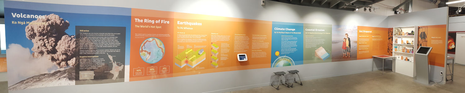
There are some large, informative displays relating to natural hazards at the East Coast LAB. Image: Andrew Penny, LEARNZ.

Kate and Andrew are next to the tsunami model which shows how tsunami form. Image: Image: Shelley Hersey, LEARNZ.

These are the potential causes of a tsunami. I wonder if a meteorite has ever caused one. Image: Andrew Penny, LEARNZ.

The science of natural hazards can help to create computer models and maps to assist with emergency planning and preparation. Image: Andrew Penny, LEARNZ.

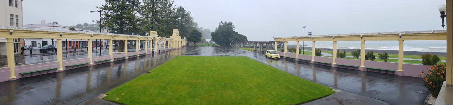
Andrew and Rakei took shelter from the wind and rain on the Napier waterfront! Image: Shelley Hersey, LEARNZ.

Bad weather can also be a hazard. There were certainly some challenging conditions today and we had to be careful on the road and when walkng near deep puddles! Image: Andrew Penny, LEARNZ.
